


Loop Trail Plan & Map
Page Navigation 
- The Borough of Mendham Loop Trail was originally conceived and designed in the early 1980s to completely connect the Borough's exisiting developed trail system.
-
The Trail is designed to provide a pedestrian path around the Borough, connecting the east and west sides of Patriot’s Path--forming a loop around the municipality.
-
It includes woodland trails, paths, and sidewalks.
-
Much of the Trail is located within the public road right-of-way or on existing sidewalks.
-
-
Provide new links to passive recreational opportunities within walking distance for Borough residents.
-
Creat new connections that make it possible for residents and children to more easily and safely walk and bike to schools and businesses throughout the Borough.
- The Loop Trail is designed to connect preserved open space areas together and access to forested properties.
- Such as the Mendham Borough School District Cosma Tract which is leased to the Borough.
- It will provide a link to Mendham Township and the Schiff Natural Land Trust’s extensive trail systems.
- The northern extent of the Loop Trail consists of Patriots’ Path, an interconnected network of trails that expand throughout Morris County.
-
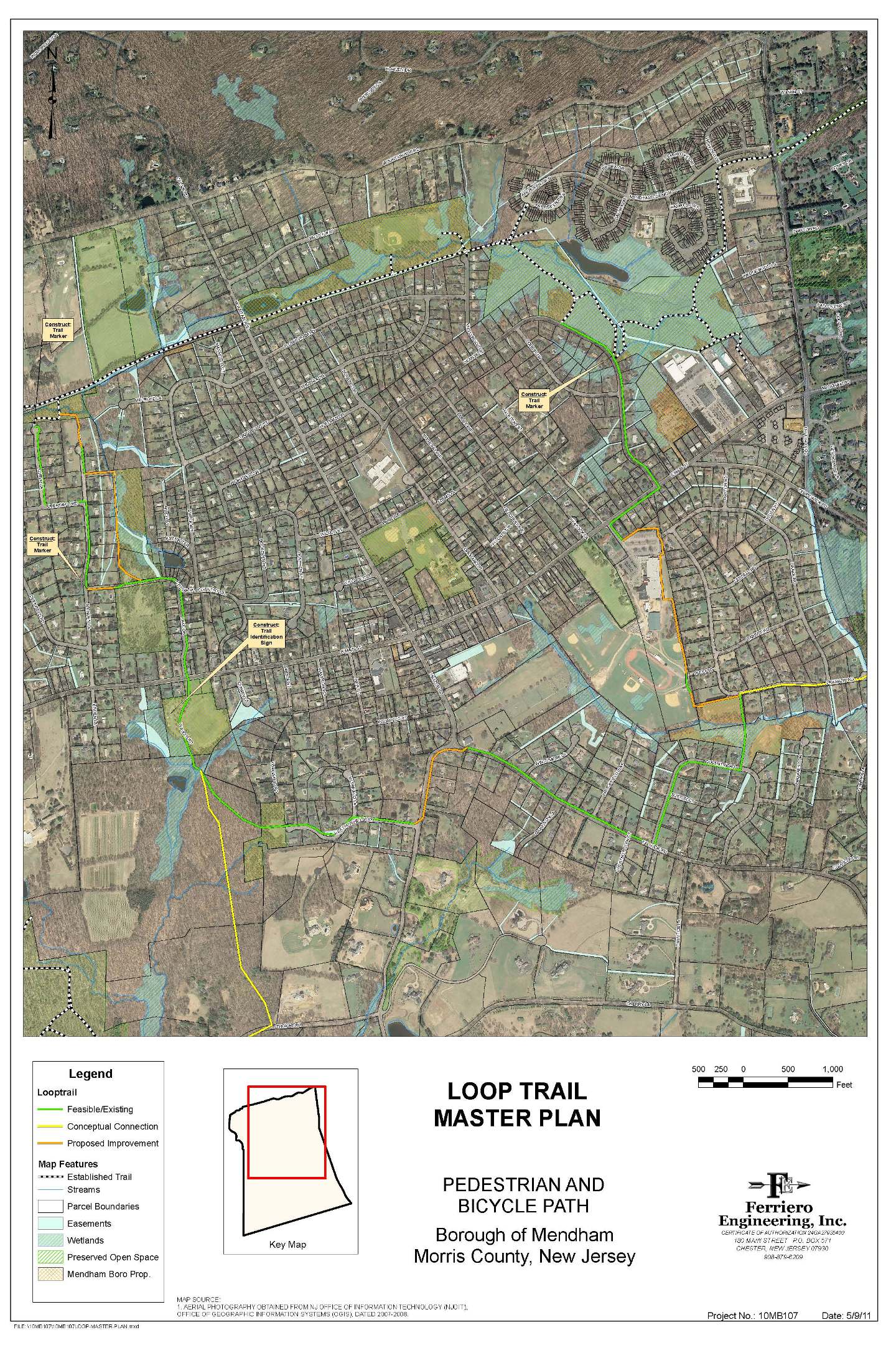
A. Patriot’s Path to Cosma Place
This segment of the trail system utilizes existing paved roadways and sidewalks located within public lands and rights of way (ROW). The Loop trailhead begins at a defined access to Patriot’s Path at the end of Loryn Lane. Trail identification signage is proposed at this location. The proposed trail continues from the intersection with Patriot’s Path along existing roadway and sidewalks on Loryn Lane and Deerfield Road. The trail then continues along for approximately 0.2 miles within the paved traveledway of Linden Lane to a proposed connection through existing Borough ROW to the Cosma Tract. An additional trail marker is proposed on Linden Lane at this location to identify the trail route. The entire length of the trail segment measures approximately 0.6 miles. In order to complete the segment, approximately 300’ of trail between Linden Lane and the existing 8’ wide gravel path through the Borough owned open space property must be defined and constructed. It is anticipated that trail surface construction will utilize a wood mulch base. This segment of the trail offers future opportunity for an alternate natural trail surface through the northern extent of a Borough owned open space tract. Approximately 0.5 miles of wooded trail may ultimately connect Cosma Place and Patriot’s Path through the northern end of Linden Lane. This connection cannot be achieved until a suitable stream crossing is provided to link Linden Lane with the northern end of the open space property. Until such time as an additional connection becomes feasible through the northern end of the Cosma tract, this segment of the trail will utilize the Loryn Lane trailhead and Linden Lane connection to provide a path from Patriot’s Path to Cosma Place.
B. Cosma Place to West Field
Public traveled ways and sidewalks characterize this segment of the proposed trail. The entire trail segment is approximately 0.36 miles long. From Cosma Place the path traverses 0.21 miles of sidewalk along Lake Drive to the Borough owned West Field property and gravel parking area. No improvements are required to implement this segment of the loop trail. A trailhead kiosk is proposed in the parking area of West Field. Future improvements to the route include potential public sidewalk from the West Field parking area to Main Street, and future traffic signage and crosswalk improvements at the intersection with Main Street.
C. West Field to Heather Hill Way
This trail segment will connect the Borough owned West Field property with Borough owned open space located at the end of Heather Hill Way. Heather Hill Way then consists of approximately 0.3 miles of sidewalk from the open space property to the intersection with Hilltop Road. Approximately 0.2 miles of this proposed segment utilizes existing natural hard surface paths that are defined through privately owned lands between the Borough owned West Field Property and open space tract at the end of Heather Hill Way. Implementation of this trail segment requires a pedestrian access easement through the privately owned property, but little else in terms of trail construction or improvement. An existing pathway through the privately owned lands may provide a future connection
from the proposed loop trail to the Schiff Natural Land Trust trail system. Although an existing natural hard surface path is partially defined along this route, an easement for pedestrian access would also be required to complete this future connection.
D. Heather Hill Way to Talmage Road
Aside from the existing crosswalk across Hilltop Road from Heather Hill Way, this entire 0.23 mile segment of the loop trail requires improvement to be used safely and effectively by pedestrians. Steeply sloping grades and existing residential improvements along the roadsides limit the construction alternatives available to achieve this connection. This segment of the hiking trail will need to be improved utilizing concrete sidewalk within the existing Hilltop Road ROW. The County of Morris owns and maintains the ROW along Hilltop Road, so future construction will require coordination and approval from Morris County. The ROW width along Hilltop Road varies, but it is predominantly 50 feet wide in the vicinity of the required improvements. The pavement area of Hilltop Road is approximately 24 feet wide, so a ROW area along the east side of the roadway 13 feet in width would encompass the sidewalk improvements. Completion of this trail segment also requires crosswalk improvements at the crest of Talmage Road in the vicinity of the intersection with Hilltop Road. Design plans, County approval, and funding will be required before this segment of the trail may be implemented to connect Heather Hill Way to Talmage Road. Future easements through private lands may provide alternate opportunities to implement a connection between Heather Hill Way and Talmage Road.
E. Talmage Road to Mendham High School
A significant portion of this trail segment utilizes existing public sidewalks for pedestrian movement along Talmage and Coventry Roads to the Borough owned open space property which borders Mendham High School. The open space tract which borders the high school property is partially improved with sidewalk and gravel paths to the public access located on Franklin Road. Less than 0.1 miles of gravel path is required and proposed to stabilize the remainder of this trail segment to define the route to the high school property along the existing soccer fields. Opportunity also exists to connect the loop trail via Franklin Road to the Tempe Wick Reserve open space tract located within the Township of Mendham. This conceptual future link will require analysis and coordination with the Township of
Mendham to determine an appropriate access trail from Franklin Road to the Tempe Wick Reserve trail network.
F. Mendham High School to Main Street
This segment of the loop trail is proposed through lands owned by the West Morris
Regional High School Board of Education (BOE). The 0.55 mile segment through the
High School property is a critical link between Main Street and the Borough owned open space tract extending to Franklin and Coventry Roads. The proposed trail through the BOE property will require an easement to the Borough to permit trail construction and pedestrian access. Detailed topographic surveying, engineering design, and coordination with BOE representatives will be required to define the trail type and route. Preliminary trail planning suggests that gravel paths and sidewalks will be best suited for this segment and will likely comprise the majority of the trail construction. The trail surface composition may vary along the proposed route to conform to BOE requirements and to minimize impact to existing areas of the property. Steep areas of the property dictate that certain sections of the trail will require stepped, ramped, or terraced walkways to accommodate the changes in grade. Trail planning through this segment will evolve to consider aspects of location, trail volume, and accessibility in order to establish the safest and most appropriate pathway possible. Future traffic signage and crosswalk improvements at the intersection with Main Street may be considered to increase pedestrian and motorist safety.
G. Main Street to Patriot’s Path
The last trail segment completes the loop around the Borough back to Patriot’s Path and measures approximately 0.57 miles in length. This section of the trail is located entirely within the public ROW and uses existing sidewalks along Main Street and Dean Road. Other than a proposed trail marker at the intersection of Patriot’s Path and potential future traffic signage modifications at the Main Street crosswalk, there are no proposed improvements necessary to implement this segment of the loop trail.


.jpg.png)

.png)


.png)
